Thanks I'll check files
Checked:
It's okCode:Please Login or Register to see the links
locked
FID 2365
GMAP3D (369MB compressed): [Only registered and activated users can see links. ]
ASR folder (from a 3790)
Nuova cartella.part1.rar (350 MB)
[Only registered and activated users can see links. ]
Nuova cartella.part2.rar (350 MB)
[Only registered and activated users can see links. ]
Nuova cartella.part3.rar (32,8 MB)
[Only registered and activated users can see links. ]
--------------------------------------------------------
D2152010A.JCV Original for nuvi 2xxx (low resolution photoreal) 426Mb
[Only registered and activated users can see links. ]
D3084000A.JCV original for nuvi 765 (Photoreal) 333Mb
[Only registered and activated users can see links. ]
D2504030A.JCV Original for nuvi 37xx (high resolution photoreal) 697Mb
[Only registered and activated users can see links. ]
------------------------------------------
[Only registered and activated users can see links. ]
-------------------------------------------
Some Locked Images:
UK & RoI:
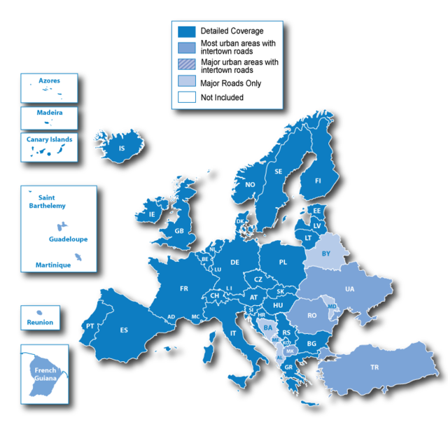
Coverage includes Great Britain, the Isle of Man, the Channel Islands, Northern Ireland and Republic of Ireland.
[Only registered and activated users can see links. ]
Iberia:
Contains detailed map coverage for Spain, Andorra, Portugal and Gibraltar.
[Only registered and activated users can see links. ]
Scandinavia + Estonia
Includes detailed maps of Denmark, Finland, Iceland, Norway and Sweden. And Special add Estonia
[Only registered and activated users can see links. ]
[Only registered and activated users can see links. ]
Italy & Greece
Includes full coverage of Italy, Vatican City State, San Marino and Greece. (no Malta)
[Only registered and activated users can see links. ]
Italy,Malta & Greece
Includes full coverage of Italy, Vatican City State, San Marino,Malta and Greece.
[Only registered and activated users can see links. ]
France
Includes France & new coverage of French Guiana and the islands of St. Barthélemy, Martinique, Guadeloupe and Réunion.
[Only registered and activated users can see links. ]
[Only registered and activated users can see links. ]
DE AT CH
Includes detailed map coverage of Germany, Austria, Switzerland
[Only registered and activated users can see links. ]
[Only registered and activated users can see links. ]
Turkey
Includes detailed map coverage of Turkey
[Only registered and activated users can see links. ]
BeNeLux
Includes detailed maps of Belgium, the Netherlands, Luxembourg
[Only registered and activated users can see links. ]
Eastern Europe (extracted size (391MB)
[Only registered and activated users can see links. ]
[Only registered and activated users can see links. ]
Western Europe (extracted size (1.74GB)
[Only registered and activated users can see links. ]
[Only registered and activated users can see links. ]
[Only registered and activated users can see links. ]
[Only registered and activated users can see links. ]
[Only registered and activated users can see links. ]
[Only registered and activated users can see links. ]
[Only registered and activated users can see links. ]
[Only registered and activated users can see links. ]
For these regions IMGs Credits and Password :huntsman
°°°°°°°°°°°°°°°°°°°°°°°°°°°°°°°°°°°°°°°°°°°°°°°°°°°°°
Ready, unlocked map for 2GB cards (size <2 000 000 000 bytes) - version I
Deleted:
- French Overseas Departments
- Finland
- Lithuania
- Latvia
- Estonia
- Belarus
- Ukraine
- Moldova
- Turkey
[Only registered and activated users can see links. ]
[Only registered and activated users can see links. ]
[Only registered and activated users can see links. ]
[Only registered and activated users can see links. ]
[Only registered and activated users can see links. ]
[Only registered and activated users can see links. ]
[Only registered and activated users can see links. ]
[Only registered and activated users can see links. ]
----------------------
unlocked map for 2GB cards (size <2 000 000 000 bytes) - version II
Deleted:
- French Overseas Departments
- Spain islands
- Portugal islands
[Only registered and activated users can see links. ]
[Only registered and activated users can see links. ]
[Only registered and activated users can see links. ]
[Only registered and activated users can see links. ]
[Only registered and activated users can see links. ]
[Only registered and activated users can see links. ]
[Only registered and activated users can see links. ]
[Only registered and activated users can see links. ]
credits and password:maffi_pl
-------------------------------------------
and credits to this thread posters and friends who provided the links
Welcome guest, is this your first visit? Click the "Create Account" button now to join.
Results 1 to 10 of 146
-
19th February 2011, 05:45 PM #1Master


- Join Date
- Jun 2009
- Location
- Bulgaria
- Age
- 58
- Posts
- 6
- Rep Power
- 0
 Garmin City Navigator Europe NT 2011.40 IMG
Torrent file CNEU_2011.40 - img + JCV + G2S + SQLite , but no file GMAP3D. Will work a few days.
Mapsource version here
[Only registered and activated users can see links. ]
MOD notes:
IMGs regions links in posts 113&105
gmapdem.img is the same than in last previous version
[Only registered and activated users can see links. ]Last edited by catymag; 1st March 2011 at 11:33 PM. Reason: added some infos
-
19th February 2011, 06:18 PM #2


You have to navigate to get to the good.
Galaxy S5 Kitkat 4.4.2 / Nuvi1200->1250 / Nuvi3790T->34xx / Nuvi 2200 / Nuvi 66 / Oregon 600
-
19th February 2011, 10:28 PM #3pietuGuest

Some changes

Last edited by pietu; 21st February 2011 at 12:36 AM.
-
20th February 2011, 02:05 AM #4pietuGuest

[Only registered and activated users can see links. ] (484.9 KB)
[Only registered and activated users can see links. ] (48,4 MB)
[Only registered and activated users can see links. ] (254,4 MB)
[Only registered and activated users can see links. ] (234,4 MB)
[Only registered and activated users can see links. ] (390 MB)
[Only registered and activated users can see links. ] (390 MB)
[Only registered and activated users can see links. ] (390 MB)
[Only registered and activated users can see links. ] (390 MB)
[Only registered and activated users can see links. ] (196,1 MB)
[Only registered and activated users can see links. ] (390 MB)
[Only registered and activated users can see links. ] (390 MB)
[Only registered and activated users can see links. ] (390 MB)
[Only registered and activated users can see links. ] (390 MB)
[Only registered and activated users can see links. ] (196,1 MB)
-
20th February 2011, 09:09 AM #5andy9838Guest

unlocked image copied to the SD card after the GARMIN folder in the machine can not find the map? is not unlocked?
-
20th February 2011, 09:13 AM #6
-
20th February 2011, 09:17 AM #7andy9838Guest
-
20th February 2011, 09:26 AM #8
-
20th February 2011, 11:33 AM #9

or guys,if he is using a phone,and map is bigger then 2gb,phone can't read or find that map or gmapsupp.img,find for mapsource Garmin City Navigator Europe NT 2011.40,then mark only lands you need or mark some of them to transfer to device but watchout that that one gmapsupp.img isn't bigger then 2gb...hope this will hepl,a lot of garmin users don't know this..
-
20th February 2011, 11:40 AM #10aekhongGuest

Yes., including GarminAsus M10.


 Likes:


Bookmarks